Maps
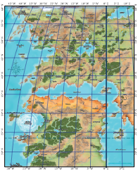
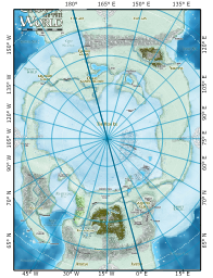
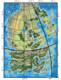
A latitude/longitude graticule has been overlaid on the following Paizo maps to help you place each region on the globe, and orient them relative to other regions.
Click on a map to enlarge. Note that the enlargements are not very big: they are not part of Paizo's Community Content, and thus cannot be redistributed. In order to protect Paizo's IP, I have made them large enough to make major features visible within the graticule, but small enough to prevent them from being generally useful. Use these as guides for making your own digital maps.
Also be sure to check out the interactive Golarion maps. Links are provided in the left sidebar.
The Inner Sea
The graticule assumes the original map from Paizo uses a Mollweide projection. Graticule lines are 5° apart and the top of the map is just above 60° N latitude. The scale bar accuracy is preserved at the lower latitudes, though as in many map that spans this much latitude the scale varies from north to south. In this map, the Tropic of Cancer passes over central Geb which is a little south of the Mana Wastes.
The Crown of the World
The graticule assumes the original map is an Azimuthal Equidistant projection and that the white, dotted line represents the arctic circle at 66.5° N. Graticule lines are 15° apart for longitude, and 5° apart for latitude. The scale bar accuracy is preserved along lines of latitude and longitude.
Tian Xia
This graticule assumes the Tian Xia map uses an Azimuthal Equidistant projection. This puts the equator just north of the mountains running from Nagajor to Xa Hoi. The scale bar is true along lines of latitude and longitude.
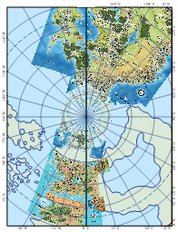
The North Pole
This north pole view of Golarion, using an Azimuthal Equidistant projection, shows the Crown of the World relative to Tian Xia and the Inner Sea Region. Note the gap between the Inner Sea and the Crown, which is canonical. The alignment between the Crown of the World and Tian Xia is problematic, and can't really be resolved. Mismatches like this are not uncommon in Paizo maps.


